Drones are unlocking efficiencies at a variety of worksites including quarries, landfills, construction sites, and more. Drone data management software is particularly helpful for earthworks teams, providing the data they need throughout a project’s life cycle, from estimating to moving materials to completion.
An all-in-one cloud-based drone data platform, like Propeller Aero, is helping earthworks companies around the world meet unprecedented project demands. Drone data is helping teams stay productive, promoting efficiencies in projects of all sizes and scopes. Here are 10 ways drone survey data and earthwork software can make your next project a success:
1. Estimating earthwork volumes. Earthworks teams need an accurate assessment of material volumes before starting work on a project—it can make the difference between a profitable and unprofitable job. Overestimating or underestimating a job can negatively impact your revenue. Propeller’s earthwork estimation tools consistently provide accurate estimates, quick cut/fill volume calculations and maps, progress tracking, and topographic contour maps.
2. Optimizing earthwork planning and reporting. No matter the size or scope of a project, you need accurate earthwork analysis and reporting. Propeller’s polygon measurement tool helps you analyze specific areas of your site, so you can generate more accurate and timely invoices for your customers while ensuring progress is on track.
3. Settling disputes. Earthworks teams that fly their worksite regularly have a detailed record of what’s been moved when it was moved, and who was responsible for it. You can refer to this audit trail if disputes arise during the project.
4. Tracking progress. Drone surveys make it much easier for earthworks teams to check construction sites against design, helping to spot issues before they become big problems.
5. Avoiding environmental fines. Earthworks teams need to consider greater environmental sustainability, not just for their reputation but also for their bottom line. Regular drone surveys help you monitor site boundaries and no-go zones closely, so you can avoid fines associated with environmental violations.
6. Improving safety. Construction is an inherently dangerous industry, but drone data is playing a role in making the worksite a safer place. For example, drone surveys reduce the need for in-person inspections, as well as ensure haul roads meet safety standards while also streamlining traffic management.
7. Troubleshooting mobile plant operations. Propeller’s earthwork software allows you to measure grades and cross-slopes directly in your web browser, helping you make necessary haul road design modifications that reduce cycle times and fuel burn.
8. Improving site accuracy. Want clearer, more readable surveys? Propeller’s software offers terrain filtering, allowing you to scrub obstructions from your data for better progress monitoring and accurate volume calculations.
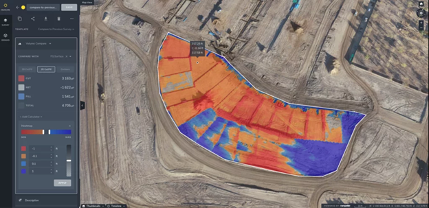
9. Measuring stockpile volumes. The Propeller Platform provides complex volume comparisons for you, offering a clear picture of where dirt is coming from and where it’s going, so you know exactly what your contractors have moved and what’s left.
10. Tracking changes in stock. Propeller’s set of volumetric tools helps you easily track changes in stock, measure erosion, and compare progress against design. The Volumetric Compare tool gives you instant visuals of how stockpiles have changed over time.
Every earthworks project, regardless of size or scope, can benefit from drone survey data. By flying your site regularly, even as frequently as every week, and uploading your data to Propeller’s all-in-one processing solution, you have access to accurate data that not only improves safety and sustainability on every job site but also keeps projects on track and on budget.


